(2)
(2)moon phase
Sun times displayed in .
Today's Best Fishing Times
Get the best fishing times for Clam River Flowage with Lake-Link's Fishing Forecast. SEE MORE
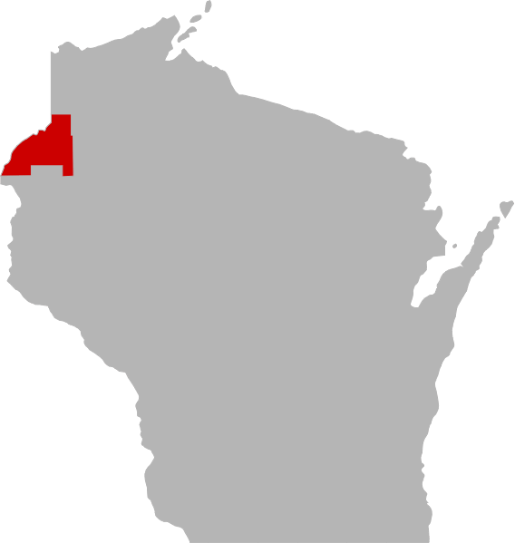
Clam River Flowage is a 359 acre lake located in Burnett County. It has a maximum depth of 29 feet. Visitors have access to the lake from a public boat landing. Fish include Panfish, Largemouth Bass, Smallmouth Bass, Northern Pike, Walleye, Sturgeon and Catfish.
Share your catch!
We want to see what you've caught on Clam River Flowage.
CLOSE TO THE LAKE!
Cheese Mountain Pizza Sale
MORE FRESH DEALS
Frequently Asked Questions About Clam River Flowage, WI
- How big is Clam River Flowage?
- How deep is Clam River Flowage?
- What kind of fish can you catch in Clam River Flowage?
- What are the closest cities to Clam River Flowage?
- Are there places to stay in the Clam River Flowage area?
- Are there topographical lake maps available Clam River Flowage?
- Are there boat launches on Clam River Flowage?
- Are there places to eat and drink near Clam River Flowage?
- What are the fishing regulations for Clam River Flowage?
- What is the bottom compostion of Clam River Flowage?
- What is the average air temp for Clam River Flowage?
- Are there any state parks near Clam River Flowage?
How big is Clam River Flowage?
Clam River Flowage is approximately 359 sq acres (1.5 sq km) in size.
How deep is Clam River Flowage?
Clam River Flowage is approximately 29 feet (8.8 m) at its deepest point with an average depth of 11 feet (3.4 m).
What kind of fish can you catch in Clam River Flowage?
Although thery may be others but anglers can expect to find a variety of fish including Channel Catfish, Lake Sturgeon, Largemouth Bass, Northern Pike, Panfish, Smallmouth Bass and Walleye in Clam River Flowage.
What are the closest cities to Clam River Flowage?
Nearby cities and towns include Webster, WI and Danbury, WI.
Are there places to stay in the Clam River Flowage area?
Are you craving a weekend escape from the hustle and bustle of city life? Or maybe you're an avid angler in search of the perfect fishing spot? Look no further! Clam River Flowage and its surrounding area offer an abundance of options to suit your needs. If you're in need of accommodation, check out our area map which highlights some of the best places to stay. And if you're looking for even more options, head on over to our Travel section. But why settle for a traditional hotel or resort when you can take your adventure to the next level by renting a RV? The open road awaits you!
More Lodging Options
More Lodging Options
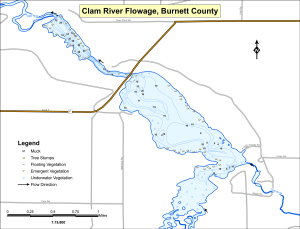
Are there topographical lake maps available Clam River Flowage?
We have an topograpical map for online viewing near the top of this page. Lake-Link Pro users can download an print a topograpical map of Clam River Flowage (.pdf format) along with 2,700 more lake maps. For more information on all the benefits of Lake-Link Pro click here.
Are there boat launches on Clam River Flowage?
We know of 1 public boat launch on Clam River Flowage. Please observe any specific lake regulations posted by the boat launch and please help keep the launch area free of litter.
Are there places to eat and drink near Clam River Flowage?
Yes, you can find numerous options in the area. Click the button below to see what's nearby.
What are the fishing regulations for Clam River Flowage?
 There are specific fishing regulations Clam River Flowage that you need to know. For complete fishing regulations visit the Wisconsin Department of Natural Resources. To report a violation call (800) 847-9367 or cell #367. Need a Wisconsin fishing license?
General Restrictions
- Catch and release fishing for largemouth and smallmouth bass is open year round unless otherwise noted.
- Motor Trolling is allowed with up to 3 hooks, baits, or lures, per angler.
What is the bottom composition of Clam River Flowage?
Clam River Flowage's bottom composition is comprised of sand (70%), muck (10%), rock (10%) and gravel (10%).What aquatic invasive species are found in Clam River Flowage?
There are some aquatic invasive species found in Clam River Flowage including Curly-Leaf Pondweed, Purple Loosestrife and Rusty Crayfish.
Join us in the fight to prevent the spread of invasive species These sneaky creatures can hitch a ride on boats, clinging onto propellers, anchor lines, and trailers. They can even survive in hidden places like bilge water and ballast tanks, or disguise themselves in dirt and sand that sticks to nets, buckets, anchors, and waders. But don't worry, we have the power to stop them in their tracks with just a few simple steps. So let's do our part and protect our waters from these unwanted invaders.
What is the average air temp for Clam River Flowage?
Looking forward to your next adventure at Clam River Flowage? Don't forget to plan ahead! Weather can be unpredictable, but we've got you covered. On average, air temperatures during this time of year range from a high around 62°F (17°C) to a low around 41°F (5°C). Of course, these are just historical averages, so be prepared for anything Mother Nature throws your way. For the most up-to-date weather information, be sure to check out our Weather Bar located at the top of this page.
Are there any state parks near Clam River Flowage?
Enjoy more of the outdoors with a visit to an area state park. There are 3 state parks in the vacinity of Clam River Flowage.
For more Wisconsin State Park information see our State Park Guide.
Clam River Flowage Reviews
Below is the word on street about Clam River Flowage.Have you been to Clam River Flowage? Why not share your personal reveiw with others?
Submit Review
alex c.

Caught A Northern With A Lamprey Attached To It. Goodby Big Fish!
Reviewed Mar 15, 2001
jimbo
Nice Perch If You Can Find Them. Walleyes Have Disappearedcompared To 5 Years Ago.
Reviewed Mar 14, 2001
More Nearby Lakes To Explore
There's more lake's to explore around Clam River Flowage...| DISTANCE | ACRES | MAX DEPTH | |
| Bluff Lake | 2.9 mi | 53 | 23 ft |
| Reed Lake | 3.6 mi | 31 | |
| Little Yellow Lake | 4.2 mi | 332 | 21 ft |
| Monson Lake T39n R18w S04 | 4.5 mi | 119 | |
| Upper North Fork Flowage | 4.8 mi | 276 | |
| Bass Lake | 4.8 mi | 222 | 6 ft |
| Kreiner Lake | 5.5 mi | 67 | 2 ft |
| Danbury Flowage | 5.7 mi | 242 | 10 ft |
| Yellow Lake | 5.8 mi | 2,283 | 31 ft |
| Lake Clayton | 6.1 mi | 17 | 13 ft |
DISCLAIMER: Lake-Link Inc assumes no responsibility or liability for any errors or omissions of the information for Clam River Flowage. Although we strive to provide the most accurate information as we can the information contained in this page is provided on an "as is" basis with no guarantees of completeness, accuracy, usefulness or timeliness.